TLP:CLEAR · Disclosure is not limited.
Israel-Gaza Regional Escalation: Situation Report, 11 October 2026
Time window: Last 7 days · Audience: General analyst · Type: Situation report · DTG: 2026-10-11 13:06Z · Overall confidence: MEDIUM
BLUF
The clearest Gaza signal is continued military entrenchment and extensive physical destruction despite reporting that the official ceasefire remains in place. September satellite imagery shows IDF outposts or demolished areas at named sites, while Hamas is reported to control about 35 percent of Gaza. A 9 October tanker strike off the UAE and contested reporting on a strike off Qatar add to regional shipping risk, but the supplied reporting does not link these incidents to Gaza or Hezbollah.
Executive summary
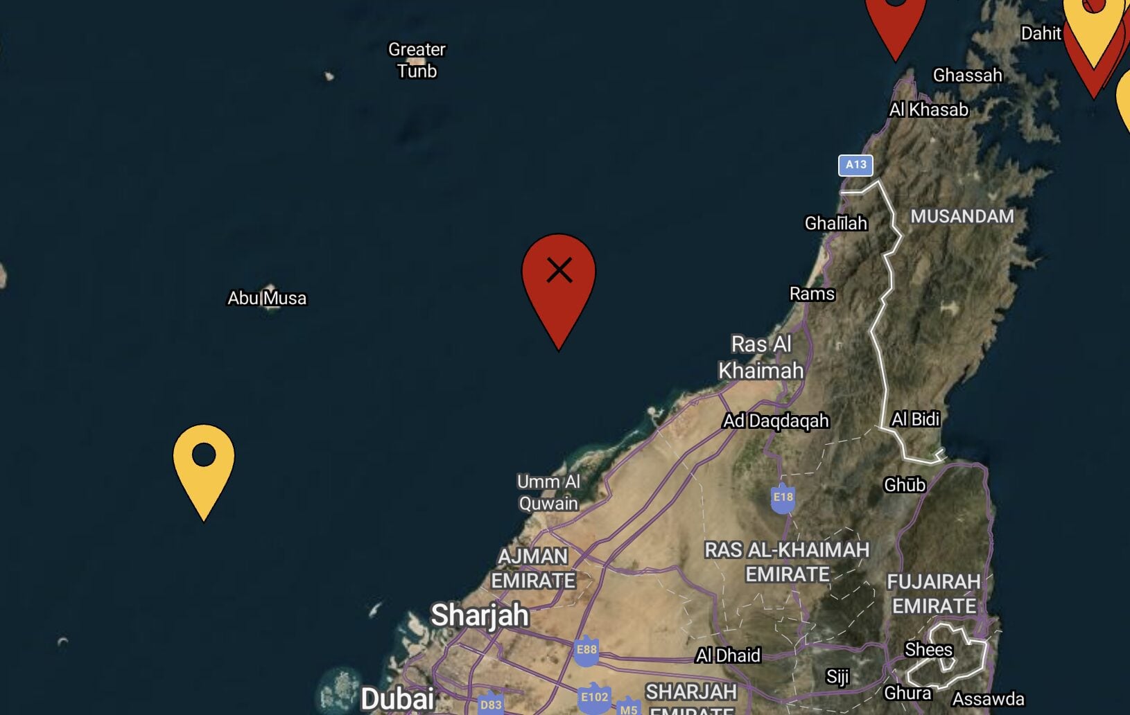
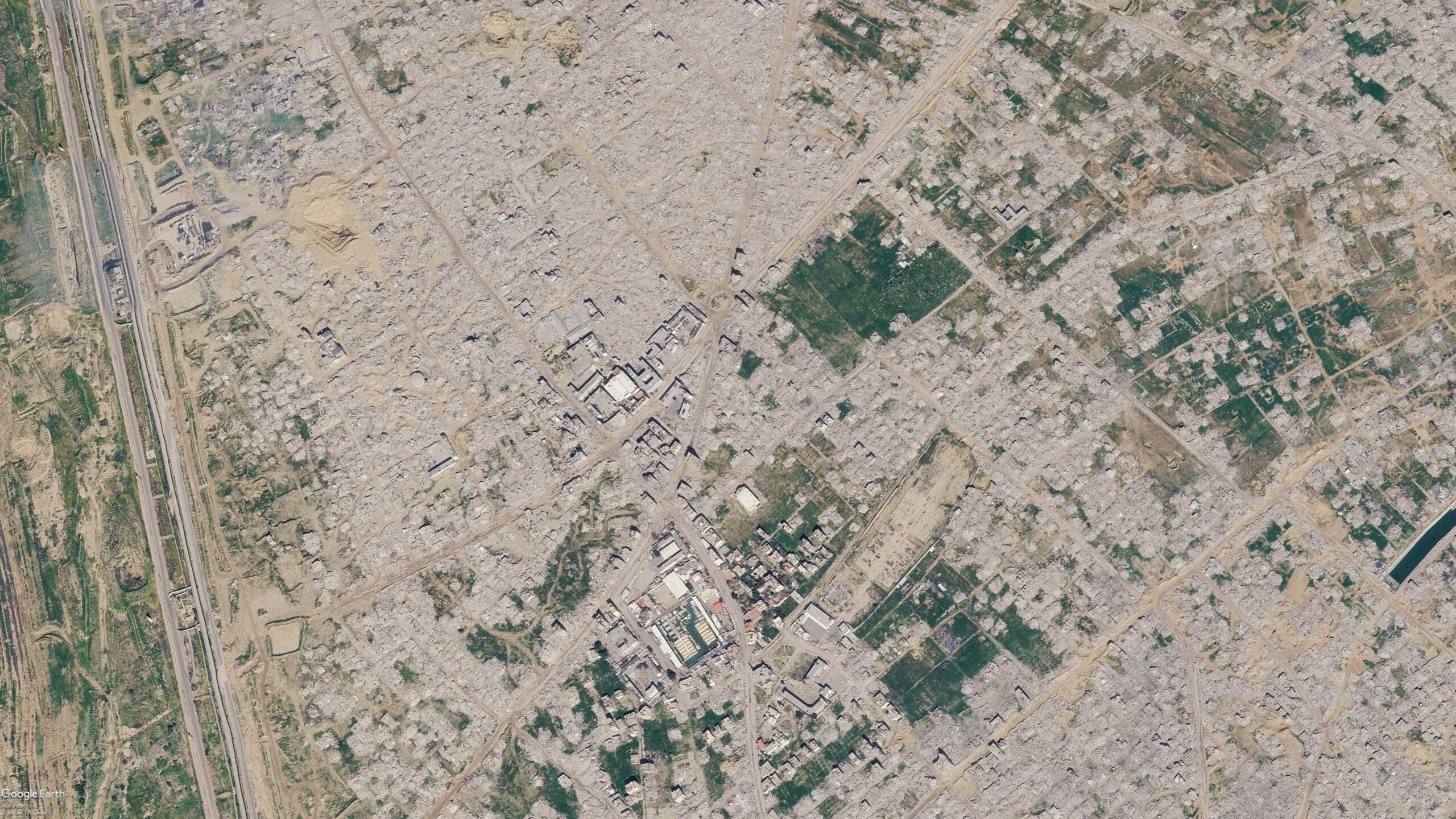
Reporting published during the period adds satellite imagery of demolitions and IDF outposts in Rafah, Bani Suheila, Shujaiya and Jabaliya. The imagery dates to September, so it establishes conditions then, not the extent of activity on 11 October. UN data cited in reporting put damage to Gaza structures at about 82 percent, with two-thirds of those structures destroyed. Separately, a vessel identified as the Panama-flagged crude supertanker GEM NO.2 was struck by an unknown projectile off the UAE on 9 October; the fire was extinguished, while crew status and the extent of damage remained unknown. Reporting on a tanker incident off Qatar conflicts over attribution, including a low-confidence IRGC claim. For southern Lebanon, the supplied material offers one think-tank assessment of Israeli forces remaining deployed as Hezbollah resists disarmament, but no corroborating operational detail.
Change from previous assessment
Since the 10 October brief, this assessment adds reporting on September imagery that depicts demolitions and IDF outposts in named Gaza locations, alongside a report that Hamas controls approximately 35 percent of Gaza. It also adds the 9 October strike on GEM NO.2 off the UAE and conflicting attribution reporting on a tanker incident off Qatar. The supplied claims do not update aid flows, the National Committee for the Administration of Gaza, or UNIFIL planning, so those parts of the prior assessment are not reassessed here.
Key judgments
- Israeli forces are likely to retain positions in parts of Gaza in the near term. September imagery shows an IDF outpost and an earthen barrier in Bani Suheila, demolition and outpost construction in Shujaiya and Jabaliya, and demolition near Rafah's municipal stadium and Tal as Sultan. Hamas is reported to control approximately 35 percent of Gaza. These reports support an assessment of continuing divided control, but do not establish the current extent of Israeli positions or prove that the depicted activity continued into October. (Confidence: medium · ASSESSED)
- I&W: Confirm if new, dated imagery shows IDF outposts or barriers still present in Bani Suheila, Shujaiya or Jabaliya. (1-3 months)
- I&W: Break if new, geolocated imagery shows those outposts dismantled and the barriers removed. (1-3 months)
- Physical destruction in Gaza is extensive. UN data cited in reporting put about 82 percent of structures in Gaza as damaged, with two-thirds of those structures destroyed; September imagery depicts demolition in Rafah, Bani Suheila, Shujaiya and Jabaliya. The damage estimate is reported through one media investigation, while the imagery provides visual evidence at specific sites rather than a new Strip-wide estimate. (Confidence: medium · REPORTED)
- I&W: Confirm if a later UN structural assessment retains the reported 82 percent damage figure and its stated denominator. (1-3 months)
- I&W: Break if the UN revises the estimate or clarifies that the reported damage figure used a different denominator. (1-3 months)
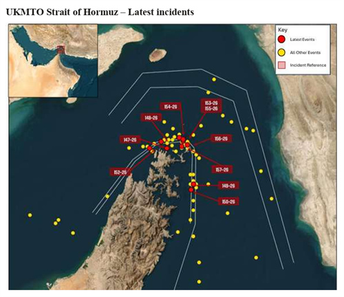
- Commercial shipping in the Gulf and waters off the UAE and Qatar faces likely elevated risk of further attacks or intimidation over the next 0-14 days. UKMTO reported a strike by an unknown projectile on GEM NO.2, about 13 nautical miles west of Al Jazeera in the UAE, on 9 October; the resulting fire was extinguished. Reporting also describes a tanker strike off Qatar, but attribution remains unresolved: one account named no attacker, while a low-confidence report said the IRGC claimed striking the Vietnamese-owned LPG tanker NV Sunshine off Ras Laffan. The United States Navy-led Joint Maritime Information Center reported more frequent attacks, but the Qatar attribution and the asserted expansion of IRGC activity beyond the Strait of Hormuz rest on weaker reporting. (Confidence: medium · ASSESSED)
- I&W: Confirm if UKMTO or the Joint Maritime Information Center reports another verified strike or shooting incident involving a named commercial vessel off the UAE or Qatar. (0-14 days)
- I&W: Break if UKMTO or an investigating authority identifies the reported UAE and Qatar incidents as non-hostile events or false alarms. (0-14 days)
- Israeli forces are likely to remain deployed in southern Lebanon in the near term while Hezbollah resists disarmament, but confidence is low. This forecast rests on a single think-tank assessment that provides no force locations, deployment scale or independently corroborated account of Hezbollah's position. (Confidence: low · ASSESSED)
- I&W: Confirm if dated reporting or imagery identifies continuing Israeli positions in southern Lebanon and a stated Hezbollah refusal to disarm. (1-3 months)
- I&W: Break if independently corroborated reporting documents an Israeli withdrawal and verified Hezbollah disarmament steps. (1-3 months)
Outlook & scenarios
Continued divided control and episodic regional incidents (60%)
Israeli forces retain positions in parts of Gaza while Hamas maintains some control, and the formal ceasefire remains in place without resolving the division on the ground. The September imagery remains the clearest evidence of military positioning and destruction. Shipping incidents remain episodic rather than developing into a sustained campaign.
Limited de-escalation (30%)
Israeli forces reduce their positions in Gaza and follow-on reporting shows fewer demolitions. No further verified tanker attack is reported off the UAE or Qatar during the near-term outlook. The current claims do not establish that progress on one front would produce restraint on the other.
Regional maritime escalation wildcard (10%)
The IRGC's reported threat to pursue vessels beyond the Strait of Hormuz is followed by repeated attacks on tankers in the wider Gulf. Verified incidents off the UAE, Qatar or other named Gulf locations would turn the current shipping risk into a broader operational disruption. This is a low-probability, high-impact scenario, and the supporting IRGC reporting is weak.
Recommendations
- Maintain a dated imagery record for the Rafah municipal stadium, Tal as Sultan, Bani Suheila, Shujaiya and Jabaliya. Separate observations of structures and outposts from claims about when or why they were destroyed.
- Track GEM NO.2 and NV Sunshine as separate incident files until vessel identity, incident time, location, crew status, damage and attribution are independently reconciled. Compare subsequent UKMTO notices with Joint Maritime Information Center updates.
- Do not treat NASA FIRMS thermal detections as proof of strikes or their cause; use them only alongside dated, geolocated reporting.
- Seek independent, dated confirmation of Israeli deployments in southern Lebanon and Hezbollah's disarmament position before raising confidence in the Lebanon assessment.
Confidence & uncertainty
Overall confidence is medium because several Gaza findings draw on dated satellite imagery, while the reported UN damage estimate provides a separate measure of destruction. UKMTO reporting, vessel identification from shipping sources and the Joint Maritime Information Center warning support the assessment of elevated shipping risk. Confidence is limited by the September date of the imagery, unresolved attribution for the Qatar tanker incident, weaker reporting on IRGC threats beyond the Strait of Hormuz, and the single-source Lebanon assessment.
Alternative analysis (red cell)
The maritime evidence may indicate several serious incidents, but it does not yet establish a generalized or sustained elevation of risk across the Gulf and waters off the UAE and Qatar. One UAE strike is confirmed but unattributed (225c5e5b-810c-495b-b75a-e24e47c29a00; 59bb691f-305e-4008-ac26-e53b9137172f), while the Qatar incident has conflicting attribution (b3da58c6-b648-4199-a13c-55c63ffcaf1e; 9c4ee4f8-6c58-429b-94bc-cd18da96146d) and the asserted geographic expansion relies on low-confidence claims (23b980bd-6963-40e3-8de3-26a2df4036e2; 69e0fddf-f9a3-4984-aa2d-f1c4a1397c4d). The more defensible assessment is localized, unresolved maritime risk pending further incidents or attribution.
Intelligence gaps
- [EEI 1.1 · UNCOVERED] Number, type and geolocated coordinates of projectiles (rockets, mortars, anti-tank guided missiles) fired from Lebanon into Israel in the last 24/72 hours, including time-stamped launch and impact locations. Recommended collection: signals/intel
- [EEI 1.2 · UNCOVERED] Satellite or aerial imagery showing movement, concentration, or forward displacement of Hezbollah-associated military assets (armored vehicles, artillery pieces, mobile rocket launchers, logistics convoys) to positions within 0-10 km of the Israel-Lebanon border. Recommended collection: satellite/imagery
- [EEI 1.3 · UNCOVERED] Intercepted or captured Hezbollah command-and-control communications or orders explicitly directing cross-border operations or coordinated strikes with Palestinian groups (time-stamped messages, unit identifiers, orders to fire/move). Recommended collection: signals/intel
- [EEI 1.4 · UNCOVERED] Observable changes in Israeli northern-front posture within Israel (numbers and types of reinforcements deployed to northern brigades, activation of reserves, air defense redeployments, evacuation orders or shelter alerts in northern towns), including timestamps and unit IDs where available. Recommended collection: human/intel
- [EEI 2.1 · UNCOVERED] Official or corroborated reports of IDF reservist mobilization and unit-level deployment orders (number of reservists called, named brigades/units ordered to deploy, deployment timelines). Recommended collection: open-source/media
- [EEI 2.2 · UNCOVERED] Satellite or ground imagery showing concentrations of IDF heavy equipment (tanks, infantry fighting vehicles, engineering vehicles), staging areas, field hospitals or forward supply dumps within X km of the Gaza border and at known crossing points. Recommended collection: satellite/imagery
- [EEI 2.3 · PARTIAL] Change in strike patterns consistent with pre-ground-attack shaping: sustained high-frequency airstrikes on tunnel networks, command nodes, coastal launch sites, and known insurgent concentrations (strike counts, munition types, locations, times). Recommended collection: open-source/media
- [EEI 2.4 · UNCOVERED] Logistics indicators: verified convoys of fuel/ammunition entering staging areas, establishment of forward logistics or medical bases, or documented requisitioning orders for bulk combat supplies with timestamps and quantities. Recommended collection: human/intel
- [EEI 3.1 · UNCOVERED] Number, participants and content of diplomatic contacts or negotiation sessions in the last 48 hours involving mediators (Egypt, Qatar, US, UN), including any proposed ceasefire text, prisoner/exchange lists, timelines or verification mechanisms. Recommended collection: diplomatic
- [EEI 3.2 · UNCOVERED] Public statements, press releases or verified communiqués from Hamas and other Gaza armed groups specifying acceptance, rejection, or conditions for a ceasefire (explicit conditions such as prisoner release lists, withdrawal terms, lifting of blockades), with timestamps and speaker attribution. Recommended collection: open-source/media
- [EEI 3.3 · UNCOVERED] Humanitarian indicators relevant to ceasefire: establishment and operation of agreed humanitarian corridors/checkpoints, number of aid deliveries admitted, civilian evacuations completed, and NGO/hospital reports of access denials or safe-passage violations. Recommended collection: humanitarian/NGO reports
- [EEI 3.4 · UNCOVERED] Operational evidence of a de facto pause: verified sustained reduction (e.g., ≥12 hours) in strikes or launches from either side in specific sectors, supported by strike/impact logs, radar tracks and incident reports. Recommended collection: open-source/media
Cited sources
[1] Bellingcat · Viral Google Maps Images Shared Widely This Week Show Gaza Ruins. We Obtained More Recent Satellite Imagery - bellingcat (B) · 1 October 2026 · sha256:2d0e4dc853e8 [2] Atlantic Council · Three years after October 7, Israel is facing inward (B) · 6 October 2026 · sha256:72b3b9b593e7 [3] gCaptain (republishing Reuters wire content) · Vessel Struck by Unknown Projectile Off UAE Coast Amid Surge in Attacks, UKMTO Says (C) · 9 October 2026 · sha256:ab2b01667e5f [4] maritime-executive.com · More Tankers Struck as IRGC Expands Threat Against Non-Compliant Vessels (F) · sha256:24ae654e496a
Source content hashes were computed at collection time; the cited text is preserved unmodified for the life of this product.
Red cell review: PARTIAL DISSENT
TLP:CLEAR